|
Sydney City Streets & Suburbs Map 262 9th (waterproof)
Sheet map, folded
Main Details
| Title |
Sydney City Streets & Suburbs Map 262 9th (waterproof)
|
| Authors and Contributors |
By (author) UBD Gregory's
|
| Series | City Map |
|---|
| Physical Properties |
| Format:Sheet map, folded | | Pages:1 | | Dimensions(mm): Height 1000,Width 690 |
|
| ISBN/Barcode |
9780731932962
|
| Audience | |
|---|
| Edition |
Ninth Edition
|
| Illustrations |
Full colour
|
|
Publishing Details |
| Publisher |
UBD Gregory's
|
| Imprint |
UBD Gregory's
|
| Publication Date |
7 October 2022 |
| Publication Country |
Australia
|
Description
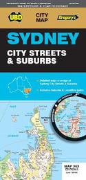
The latest edition of the Sydney City Streets and Suburbs Maphas been fully revised and updated and includes coverage at scales of 1:25 000 and 1: 100 000; One side features mapping of Sydney city and surrounding suburbs at a scale of 1: 25 000 with coverage along the coast from Dee Why in the north to Malabar in the south; Inland from Gordon in the north to Kogarah in the south; North Head in the east and west of the city to Haberfield and Russell Lea; The other side features Sydney suburban coverage at a scale of 1:100 000 from Gosford in the north Tahmoor in the south; Springwood in the west, and along the coast from Umina Beach in the north to Coalcliff in the south, with an index to the suburbs & localities on these maps. With all this information contained in this one handy sized fold out map this is an essential tool to have when travelling in and around Sydney.
|